


According to https://www.smithsonianmag.com/innovation/mapping-rios-favelas-180959816/ Rocinha is in the process of being mapped in a project called “Tá no Mapa” (it’s on the map).


Back to cartography....
When last we visted cartography, we talked about mental maps - cartography you carry in your head. If your culture relies on mental maps, it can be very difficult for outsiders to recognize your cartographic skills. Which is why there are almost no pre-colonial African maps.
“Various indigenous communities ..in .. Africa have their own cartographic traditions, which are frequently stored within songs, stories and rituals” it says at https://academicjournals.org/journal/AJHC/article-full-text/58F548754869 “The indigenous peoples of Africa largely practiced oral cartography rather than the contemporary hard copy or digital cartography we are so used to. Nonetheless, the deftness with which the indigenous people verbalized their cartographic or geographic knowledge created an incredible and indelible mental map in the minds of recipients of such information.”
So they didn’t write it down. They carried it in their minds….which means I have very few pictures to show you. One of the few solid cartographic remnants is this (Below):
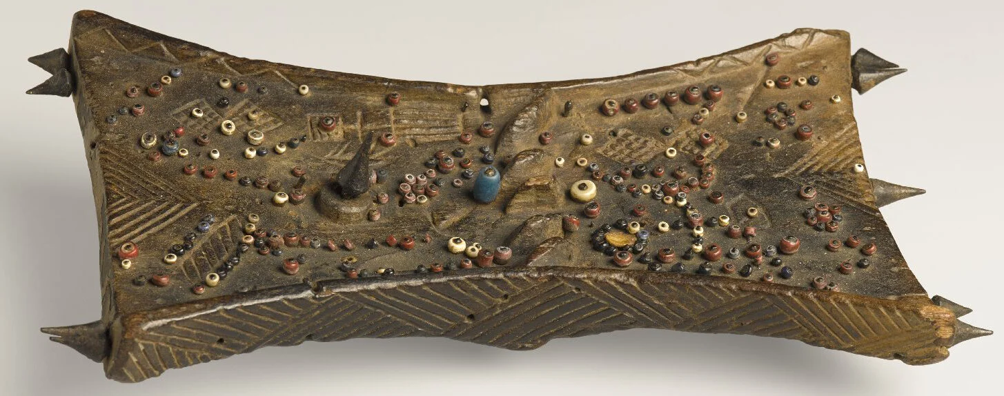
(WIKI) Lukasa memory boards are wooden tablets covered with multicolored beads & shells, or are incised or embossed with carved symbols. The colors and configurations of beads or ideograms stimulate the recollection of important people, places, things, relationships and events . A lukasa serves as an archive for the topographical and chronological mapping of political histories.
So, more of a history text than a map.
The best evidence we have of African cartographic skills are found in the writings of some early European explorers. The explorers would ask locals where to find some river or mountain, and the local would use a stick to draw out a map on the ground. But “during the 19th and early 20th centuries, map-making European travellers, missionaries and scholars depended profoundly on the geographical knowledge provided by indigenous informants in Africa. In their diaries, travel accounts and maps, however, Europeans tended to conceal their dependence and depict African authorities as unreliable” https://history.icaci.org/wp-content/uploads/2016/09/Fritsch_Voigt.pdf
However, at the DECOLONIAL ATLAS https://decolonialatlas.wordpress.com/2016/05/21/east-african-ground-maps/ we find that:
The scene of Africans drawing ground maps to the profound surprise of Europeans is a recurring theme of the exploration literature. The German geographer Karl Weule was “overwhelmed” by the number of maps members of his caravan produced during a six-month research expedition through German East Africa in 1906. Between marches, he supplied his carriers with paper and pencils to see what they would draw. This is the map made by a Mambwe man named Sabatele, originally from the southern shore of Lake Tanganyika near the present Tanzania-Zambia border. The map, which traces caravan routes across Tanzania, was made in Lindi at the very beginning of Weule’s expedition. Weule notes that Sabatele’s map was oriented with south at the top, but he turned it around 180 degrees “in order to bring it into agreement with our maps.” (Below, the map and explanation, which I have to admit I can’t quite follow):

Which brings us to toponymy, which means the place-names of a region and the etymological study of these names. Africans had descriptive names for places (probably made them easier to remember), but Europeans came in and either completely renamed these places or corrupted them so they no longer made sense. For example, the place now called Victoria Falls was originally Mosi-oa-Tunya, translated as ‘The Smoke That Thunders’. Emtshonalanga (meaning ‘toward the setting sun’ ) was distorted to Mashonaland. ….just like so many Europeans had their family names mangled by the officials at Ellis Island.
If you find this interesting, you can go to…..
https://press.uchicago.edu/books/HOC/HOC_V2_B3/HOC_VOLUME2_Book3_chapter5.pdf