


Maps in Stone & Clay
There are maps from prehistoric ages which have been etched into stone and clay. Unfortunately, none of them have map keys, dates or any clues as to where there be dragons. So figuring out meanings is not easy. Here are some maps, some copied explanations (in italics), and my thoughts. Take a look…..

1. (Above) Known as the Babylonian Map of the World this is the oldest known world map (600BCE). This website - https://www.ancient-origins.net/ancient-places-asia/babylonian-map-world-sheds-light-ancient-perspectives-002135 - has a wonderful explanation, if you’re interested.
Then we have the Bedolina Map (Below)
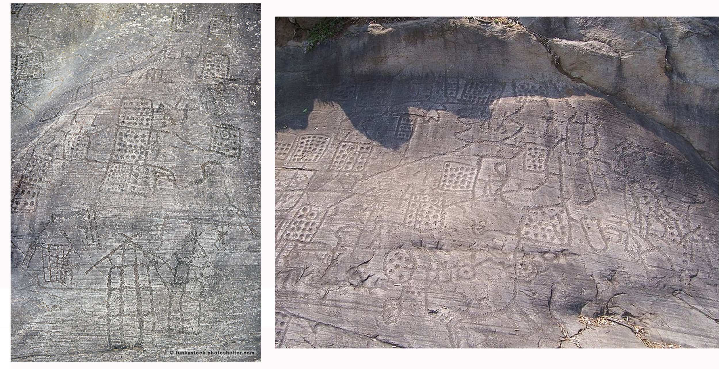
2. condensed from Wiki: The Bedolina Map is a famous engraved prehistoric rock, part of the Camonica Valley Petroglyph Complex (in Bedolina, in the Alps, Italian side, Lombardy region) It is one of the most ancient topographic maps interpreted as the depiction of cultivated plots, mountain paths and villages. The rock, a flat surface of Permian sandstone polished by the Pleistocene glacier, is 9 m long and 4 m wide. A total of 109 figures were carved during the late Bronze Age and the Iron Age (1000-200 BC),

(Above) The Bedolina Map, another view of the famous ancient stone map. You can certainly see streets and houses and fields….but no one can be sure it’s REALLY a map. This is one that I would love to see in person, knowing from experience how difficult it is to accurately photograph old stone etchings. Next….

3. Catalhoyuk Mural Map(Above) This mural was long-assumed to be a map. See explanation (below):

This illustration shows a drawing of a wall painting unearthed at the archaeological site of Catal Huyuk. The mural may be the world’s first map—of a two-peaked volcano just beyond the square buildings of an ancient community. Stephanie Meece has strongly challenged that assumption.
This website gives a good explanation of the history of the map: https://blog.education.nationalgeographic.org/2014/01/15/explosive-evidence-for-the-worlds-oldest-map/
And this website describes exactly why it’s absolutely NOT a map: https://makingmaps.net/2008/10/13/cartocacoethes-why-the-worlds-oldest-map-isnt-a-map/
So you can see the confusion. Science keeps coming up with new information, new insights. When I first saw the map (Below) on Atlas Obscura, I figured it was some hoax. But further reading says it’s probably legit.

4. Map Rock (Above) Atlas Obscura tells us: This large Basalt rock was carved by ancient Shoshone-Bannock peoples to map the area of the upper Snake River, possibly as long as 12,000 years ago. It depicts the Snake and Salmon Rivers, as well as the animals and tribes that inhabited the territories in between. No one can decisively say what the carving’s purpose was. The carving might have provided a reference point for travelers and hunters—just by looking at the map they would have been able to navigate the region. There are also theories that the petroglyph was intended to match up with the constellations, and that it could even be used to track the migrations of buffalo, deer, sheep, and elk herds. Other historians offer that it’s unlikely the Shoshone would have put all their hunting knowledge on a map so close to a popular trail for all to see. They believe the rock carving may be more cosmic; a map of all the beings that inhabited the river valley. Next….
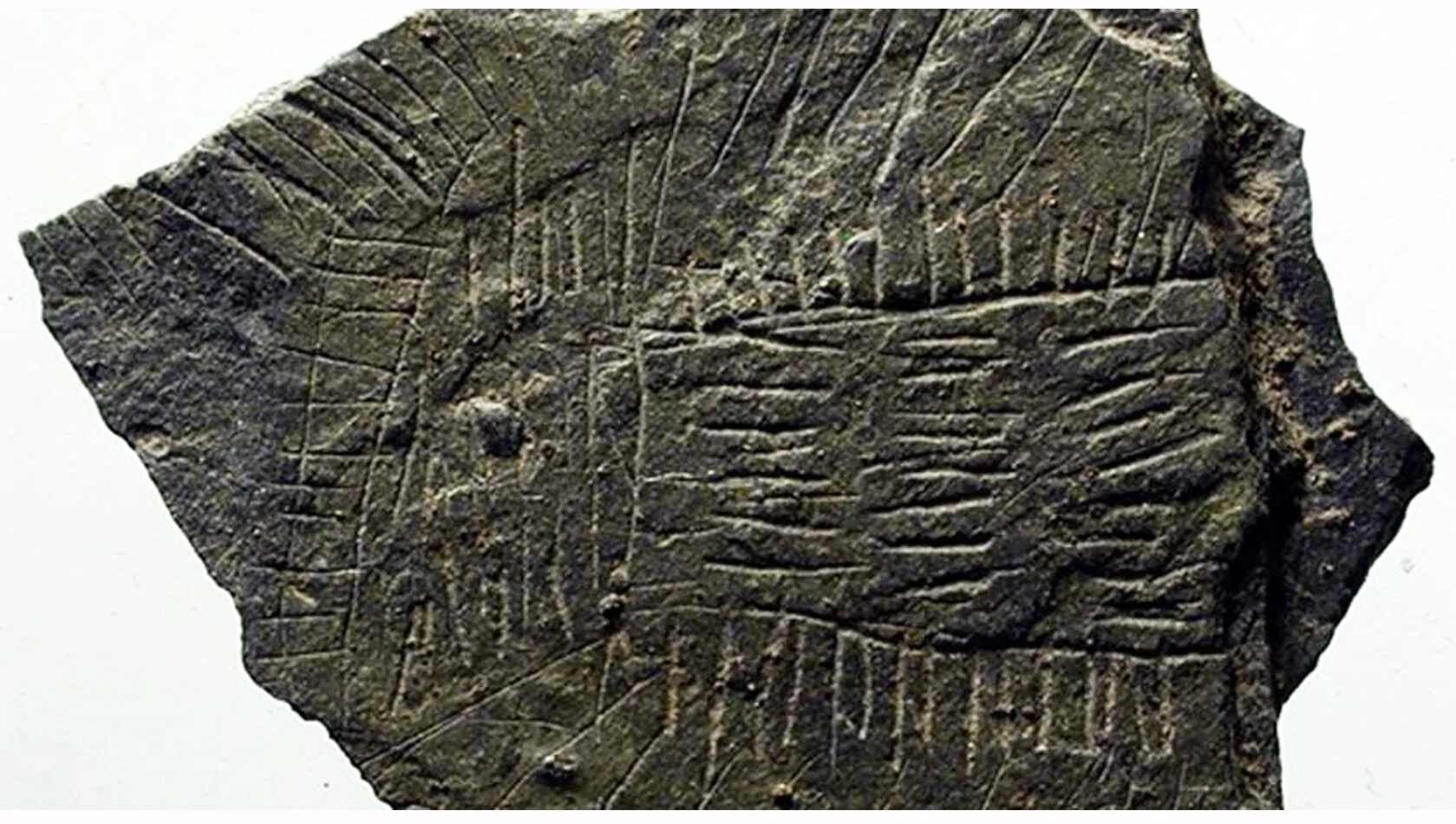
(Below) 5. Magdalenian Hunter Map

How do researchers know that the Catalhoyuk Mural is NOT map, but they can tell that the scratchings on this stone represent bridges and caves?
https://www.oldest.org/geography/maps/
Created around c.14,000 BCE in Navarre, Spain, possibly Magdalenian hunter-gatherers
The map engraved into a hand-sized rock found in the Abauntz Lamizulo cave in the Navarre region of Spain is believed to be the oldest map ever found in Western Europe. The rock was initially discovered in 1994 but it took researchers about 15 years (2009) to decipher the meaning of the etched lines. According to the research team led by Pilar Utrilla from the University of Zaragoza in Spain, “All of these engravings could be a sketch or a simple map of the area around the cave. It could represent the plan for a coming hunt or perhaps a narrative story of one that had already happened.”

Now we get to some that are wearing very big assumptions, at least to my mind. Please understand - I’m not questioning their authenticity, I just cannot see the cartography in them.
6. (Above) The Mammoth Tusk Map https://www.oldest.org/geography/maps/ (created c.25,000 BCE) from the village of Pavlov in the Czech Republic is believed to be the oldest known map in the world. While archaeologists aren’t completely sure, the markings on the tusk may have depicted the landscape of Pavlov at the time. Researchers also think that the mammoth tusk was used as a hunting map.
The curved markings are thought to represent the Dyje (Thaya) river. There are also symbols that show clay slopes that disappeared in the 20th century after being used to make a brick kiln. The map also shows the foothills where the river met the clay slopes and is represented by a double circle.
https://www.realmofhistory.com/2016/10/22/5000-year-old-stone-map-denmark/
7 (Above) Danish Map Stone Found by archaeology students in Bornholm (a Danish island in the Baltic Sea) at the Neolithic shrine of Vasagård. Showcasing etched lines with different patterns, the stone was later analysed by researchers at the National Museum of Denmark. This object was revealed to be a 5,000-year old map. It probably presents the topographic details of a particular patch on the island, between 2900-2700 BC.
however…….
There is a stone map from a later time which I find very interesting (Below):

8. The Forma Urbis Romae (aka Severan Marble Plan) was a huge marble map, around 60ft wide and 45ft high. It was made between 205 and 208CE and hung on the inside wall of a temple. Based on property records, it was amazingly detailed, showing the names and plans of public buildings, streets, and private homes.
So this was not a prehistoric relic. This was created during the Common Era (CE). But like so many manuscripts and maps from that time, it has not survived intact. After the fall of Rome (400 CE) pieces of the marble were removed and used as building materials or to make lime. Today, only about 10% of the map survives. You can find more info at:
http://socks-studio.com/2018/11/04/forma-urbis-romae/ which has images showing how the parts fit together like this (Below)
and http://formaurbis.stanford.edu/ where all 1,186 surviving fragments are now online!
This one really intrigues me. I’ll put this one aside in my files of For Future Projects.
More next week, Contact me at dianesavona@aol.com